By Jeremy Sollars
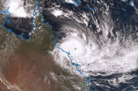
Southern Downs and Granite Belt locals are closely watching the path of Cyclone Oma as it nears the Queensland Coast this week but the Bureau of Meteorology (BOM) has warned against getting our hopes up too high for widespread rainfall in our region in the coming days on the back of the cyclone.
BOM forecaster Kimba Wong told the Free Times today, Wednesday 20 February, that it was far too early to say what rainfall Oma might bring west of the Great Dividing Range.
But she did say if rain is coming our way it is likely to be in the early part of next week, although at this stage showers are forecast for the weekend for the Warwick and Stanthorpe areas.
“At this stage Severe Tropical Cyclone Oma is a Category Three cyclone and is tracking south-west of New Caledonia,” Kimba said.
“It’s about 1140 kilometres north of Brisbane and is expected to track slowly to the south west but if and where it may make landfall is uncertain.
“We are already seeing some effects along the Queensland coast in the form of increased ocean swells.
“We’re expecting the cyclone will bring some heavy rainfall along the coast at the weekend, basically anywhere south of Gladstone.
“That rainfall could later extend to the ranges and to the adjacent inland but how heavy it’s going to be and where it’s going to fall is really uncertain at this point in time.
“If the Southern Downs and Granite Belt are going to see any real rainfall it’s likely to be from the start of next week and not so much this weekend.
“But of course that could all change in the next few days.”
• Check out a special report on the state of the region’s water supplies in this week’s edition of the Southern Free Times, out tomorrow, Thursday 21 February…


